Your cart is currently empty!
Category: econlockhatchee
-
Econlockhatchee River (lower) — Failed Trip
The Econ has not been kind to me this week. After failing earlier in an attempt to paddle the upper stretch, I returned this morning for the lower segment, which is 11-miles and runs from Snow Hill Road to State Road 46, a short ways down the St. Johns River from where the Econ flows into it.
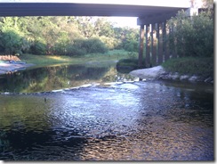
The put-in at Snow Hill Road is very nice, with gravel entries on either side of the road and under the bridge.
Despite some rain during the week, the water level was still very low when I arrived, so low that the little dam under the bridge was visible.
Water level and debris had been the problem when I tried to paddle the upper segment, but I decided to try anyway. The current water level had been okay for paddling the middle segment that runs through the Little Big Econ State Forest, so I figured it was worth a try.
Because the shore of the put-in below the little dam is mostly rock and concrete for erosion control, I put in above the dam and "shot the rapids" — this is Florida, we take what we can get.
Shortly after taking off, only a few minutes down river, I come to a tree mostly blocking the way, but it’s been down a while and previous paddlers have cleared some of it near the left bank and there’s about six or eight feet of clear water on that side.
As I get closer, I see that there’s a stump dead center of this cleared space and it looks over a foot across, so I start pondering how to get by it; is my better track going to be on the left near shore or on the right toward open water? With the current pushing me toward the gap, I look down river to see what’s next and choose my line … then I notice something and have a new thing to ponder:
Why does a stump need eyes?
This is, indeed, a riddle … a quandary, even, that I puzzle over as the stump slowly sinks out of sight.
I stop paddling as the current takes me through the gap and I look down.
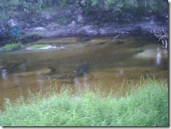
Under two, maybe three, feet of tea-colored water, half a paddle-length from the edge of my boat, is an eat-me category alligator. (Actually, from my perspective at the time, he looks more like he’s in the Betty White’s Cow category.)
He’s not as big as my boat, a 16.5′ Tarpon, but he’s bigger than most of my boat, so my heart’s racing a bit.
Now, intellectually, I know that he doesn’t want to hurt me and the reason he’s down on the bottom is so I won’t see him and will leave him alone. I know this … but fresh in my mind at the time is this message from over on the Green Wave about a gator surfacing and putting four holes in the bow of 14.5′ Perception at Alexander Springs.
I’m sure the gator in that incident wasn’t looking to hurt anyone, he just got startled and wanted to get away, so he lashed out at what he thought was the threat and then retreated.
So here I am floating by my gator today, trying ever so hard not to appear threatening (or tasty). In fact, I’m thinking to myself: "Hello, Mr. Alligator — this is just a big, blue log floating innocently down the river; soon it will be gone and you can go on about your business. Pay no attention to that mammal on top of the log, he tastes bad and is high in cholesterol."
Once past, I breathe a sigh of relief and round the next bend, glad to put him behind me. As I round the bend, I startle a deer drinking at the shoreline. She stares at me for a split-second, then bounds off into the brush. And it’s at this point that I remember I have a camera, so I head for the beach where the deer was drinking, tie up my kayak and walk back along the shoreline (keeping some distance from the actual water) until I find the alligator again — he’d drifted a bit downstream from where I first saw him. He’s still submerged, but is visible in the pictures:
As I get back in the boat and start paddling again, I begin to think:
Narrow river + shallow water + large alligators + solo paddler = ?
What do these things add up to? Stupid people doing stupid things.
See, I have no doubt at all that I’ve been on the water with gators that big before … many times. I’ve probably paddled right over them. The difference here is that the water’s not deep enough and the river’s not wide enough for the gator to get far enough from me for him to feel safe … and that’s when he’s going to hurt me, when he thinks I’m a threat and he can’t get away.
I’m barely into this trip and I’m thinking about another eleven miles of narrow, shallow water … what’s the likelihood in these conditions that I’ll be paddling hard and deep to get around some obstruction and whack one of these guys in the head with my paddle? Or that I’ll be unable to see below the surface ahead of me due to the sun’s glare and wind up running into one? Do I like these odds?
So, since one of my life-goals is to not be the guy on the six o’clock news story that everyone else in town shakes their head and mutters "dumb ass" about, I decide this isn’t the right time to take this trip. On another day, when there’s more water and maybe another paddler, I’ll be back.
At the time, though, I have another problem. Ahead of me is eleven miles of shallow, narrow water with an unknown number of large alligators … behind me might only be a few hundred yards of paddling, but I know exactly what’s in the very shallow, very narrow river.
I start paddling back, keeping a watchful eye out … no gator. I pull onto the bank a couple times so I can walk ahead and scout the water … no gator. I get past the area that I first saw him in … no gator. I get to within view of the dam … no gator. I get through the gap in the dam, under the Snow Hill Road bridge and up to the beach … no gator.
So the question in my mind for the rest of the day: I didn’t see him, so how close to the bottom of my boat was he when I went right over him?
-
Econlockhatchee River (upper) — Failed Trip
If the trip was a failure, why am I posting it? In fact, if it can’t be called a trip at all, with barely twenty minutes on the water, why am I posting it? Well, here’s what happened and why.
I’m on vacation this week and wanted to paddle several different routes to post about, including the full (navigable) length of the Econlockhatchee River. Last week I paddled the middle segment and really wanted to paddle the upper today, but the upper part of the Econ can be tricky, with low water and a lot of debris.
Over the weekend, I stopped by to look at both of the put-ins on Highway 50 — Blanchard Park and Hidden River RV. Blanchard Park is on the Little Econ and Hidden River is on the Big Econ — the two rivers meet at highway 419, entering the Little Big Econ State Forest (hence the silly name for the forest):
Blanchard Park was right out — the water level was very low and every bend was clogged with growth. There’d be no putting in here.
Hidden River was worse — I didn’t even see the water, just spoke to the manager who told me they weren’t putting in because of the low water.
Not to be deterred, I figured I’d just put in at 419 and paddle upstream as far as I could. I’d just paddled 419 to Snow Hill Road the week before, so I should be able to get some distance upstream from there before it got too bad, right?
Well, about twenty yards up the Little Econ I find the first obstruction — completely blocking the river, so I have to pull over. Around the next bend, there’s another one and I can see two more beyond it. Little Econ’s clearly not an option, let’s try the Big Econ.
Here it’s worse — I get to the first blockage and can see three more beyond it. One of which I might be able to paddle around, but the others are completely blocking the river.
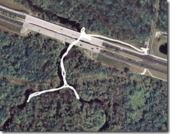 View in Google Earth
(download Google Earth)At this point, I realize I’m not going to paddle the upper stretch today, so I head back and start thinking about what to do instead. I could pass 419 and paddle the middle-segment again, but I just did that last week and I want something new to blog about. Besides, since my plan was to paddle upstream and then back, I hadn’t made any plans with kitten for her to pick me up.
So I packed things up and headed to Moss Park to paddle Lake Hart.
Now, why did I bother posting this for a trip that went nowhere when I wound up paddling someplace else?
When I started paddling twenty-some years ago, all the "trip reports" were in magazines. As I read about those trips and then took my own, I saw a disconnect — there was something missing.
The stories in the magazines were of only two flavors: the trip either went perfectly or catastrophically. Meaning, it was all cotton-candy clouds and pink bunnies showing up at the campsite come sundown; or, it was lost at sea for seven days, praying for rain to drink and trying to take down seagulls with a paddle.
When I started taking my own trips, it was mostly solitary. I didn’t have a family background of camping or paddling, so I was learning it all from scratch on my own — and my trips didn’t go like those in the magazine. There were no pink bunnies. I forgot things, I lost things, I tipped the boat over — I set fire to my tent once (a little bit) … and I started to wonder if I was completely incompetent at this outdoors-stuff.
Over time, as I met other paddlers and we shared stories, I realized that virtually every trip has something go wrong, that every paddler screws up once in a while, and that the magazines didn’t include that sort of thing because of limited space and the belief that most people don’t want to read about the mishaps.
I see the same thing on the Internet today. The mishaps and mistakes tend to get edited out and the Trips That Never Were aren’t reported.
But those mishaps and mistakes are good, valuable information. As a software developer I take a look back at every project and try to find the Lessons Learned — places were we screwed up, so we can remember them next time and try not to do it again. But those lessons only benefit others if they’re shared.
So that’s what I decided to do with this blog — as part of every trip report, I’m going to include what went wrong. And why I think it went wrong and what I plan to do to keep it from happening again.
Maybe, someday, someone’ll be setting up camp and say to themselves: "Wait a minute … this is how that dumb-ass burnt down his tent …" — and won’t make the same mistakes I have. (It didn’t burn down; it just burnt a little bit.)
What did I learn from this morning? Well, two things:
First, I should have listened to the guy at Hidden River. He’s there by the water every day and he told me the river was too low.
Second, even if the water conditions were better, I should have used a different boat. Under perfect conditions, I might have been able to paddle that route in the 16.5′ Tarpon, but it probably wasn’t the best choice. I should have taken my daughter’s 9′ Swifty, which would have made it a lot easier to pull over things, and might’ve changed a dismal failure to something challenging and fun.
There’s no such thing as a boat that’s good in all environments, and even though I prefer the Tarpon (shoving my 6′-2" self into the Swifty’s cockpit is a chore), it wasn’t the right boat for this segment of the river on this day.
-
Econlockhatchee River (middle)
Today’s activities started as a trip to the dog park with the furry family members. If you’re in Central Florida with a dog, Fleet Peeple’s Park in Winter Park is where to go. This is a huge off-leash park with lake access — absolute heaven for the puppies.
So we loaded up the car with a Border Collie, a German Shepherd and a Huskie/wolf-mix.
Yes, we have the dog to herd the sheep, the dog to guard the sheep and the dog to eat the sheep — we’re only missing the sheep … but we do have seven cats in the house, so I suppose that makes up for it.
Unfortunately, the posted off-leash hours don’t include from 10AM to 4PM on weekends and holidays — it’s technically an on-leash park at those times. This normally isn’t enforced, but today someone was having a cook-out / party there and complained, so the ranger had to enforce the rule. The dogs were disappointed.
After a short stop at another dog park (no lake), we headed home and I decided to take the boat out for a few hours.
Econlockhatchee River (middle segment)
Florida Greenways and Trails Guide
The Econlockhatchee (Econ) can be divided into three segments for paddling, this middle segment runs from S.R. 419 in Oviedo to Snow Hill Road in Chuluota:
The Econ’s a tributary of the St. John’s River, so it runs mostly north. This segment runs north from 419, then turns east to Snow Hill Road, flowing through the Little Big Econ State Forest (not a typo). Most of the route being state forest, there’s only one point, other than the put-ins where human construction impinges on the natural beauty.
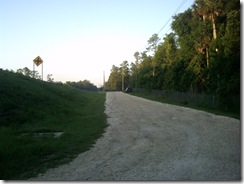
Access at 419 is just east of the bridge: It’s a few hundred feet from the parking to the water, but down a gentle, grass slope. From here, you can paddle upstream (South) towards Highway 50 or downstream (North and then East) to the Snow Hill Road access (about 8 miles), which is the direction I took. The upstream route is more overgrown and less-travelled, though.
Once out of site of the bridge, the human world disappears and you enter the real Florida, not the plastic of the theme parks:
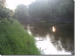
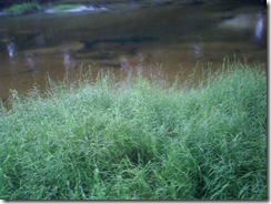
 This is a blackwater river, which means that the tannins make the water a deep brown or black when it’s deep; and it’s fed mostly by run-off, not springs, so the water level is very dependent on the rains. This being May, the end of the dry season, the water level was quite low, making the bottom visible for most of the trip — since the water’s so murky seeing bottom means a depth of only a foot or two.With the water so low, there were plenty of white sand beaches and sandbars that would make excellent camping spots. In Florida, it’s legal to camp below the high-water mark. Speaking of the high-water mark:
 Most of the route has the high, steep banks cut by river running deep when the rains come and a lot of the trees you go under in May you’ll be pulling over come August or September:
 Midway through the trip, the river turns from a northerly to easterly course and fully enters the State Forest. This is the area where there’s the most wildlife and where I’ve seen most of the alligators on this route. On today’s trip we only saw one gator, but he was big enough to satisfy me.
I place alligators into three categories. First, there’s “cute” — these are the ones that are interesting to look at and small enough that they don’t even give me pause. Next there’s “hurt-me” — these guys are big enough where I keep some distance, because I know if I scare them they might attack out of fear or cause some damage trying to get away. Finally, there’s the “eat-me”-category — these are the ones that could be considering how I’d taste after I marinated under a sunken log for a couple weeks.
Now, in general, alligators are shy and want nothing to do with people — and attacks on people are usually the result of the people doing something incredibly stupid. Take the guy in South Florida who was attacked after going swimming naked in a pond in the middle of the night — then the other guy was attacked after going swimming naked in a pond in the middle of the night … wait, that was the same guy. He did it twice. Like I said: stupid people doing stupid things.
Just the same, when they reach a certain size, it’s best to leave them be.
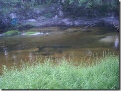
The gator we saw today definitely fell into the “eat-me” category. We came around a bend and he was near shore with his head and a couple feet of back out of the water sunning. As we glided past, he slowly sank lower and lower into the water until he disappeared.
Midway through the easterly stretch, you’ll come across the only sign of human construction between the two access points. Several trails through the State Forest converge at a pedestrian bridge across the river:
 This is a good spot to get out and stretch your legs for a bit or hike along the trails.
About a dozen or so bends in the river past the pedestrian bridge you’ll sight the Snow Hill Road bridge and the access point there:
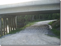
 The banks here are steeper than at the 419 bridge, so the county’s added erosion-control measures under the bridge:
 The concrete and wire on the slope will tear up the bottom of a boat, so I was happy to see that they’d covered part of it with soil and grass to make a path to the water. The last time I was here, the slope on the right was all rock and wire, so I had to pull up through the trees far to the side — the six-inch banana spider whose web I stumbled through wasn’t happy about that. This time it was much easier.
Today’s trip took a bit over two hours — if you paddle easy or stop frequently it could last three or four.
The river bends a lot and there are frequent obstructions so intermediate paddling skills are called for, especially at high-water when you won’t be able to get out and stand in the water to get past obstacles.
If you’re looking for a taste of wild Florida, this is a good choice.
-
Introduction
This site was born out of my frustration with being unable to find paddling sites that provided all the information I’d like to have about a new destination.
For instance, I’ve never seen a description of taking out at Wekiva Springs State Park that lays out just how painful the two-hundred yard uphill trudge through soft sand from the river back to the parking lot will be. Or that the Snow Hill Road take-out on the Econlockhatchee River has been rebuilt by the County with anti-erosion measures that will tear up the bottom of a boat.
Good maps, both road maps to the put-in or take-out and maps of the water itself seem unusually hard to find, as well.
So in these trip reports I’m going to try to provide the kind of information I’d be looking for when investigating a new destination … hopefully you’ll find it useful as well.


