Your cart is currently empty!
Category: florida
-
Florida Keys
With a new car that gets much better mileage than my V8 Mountainer (even if a 16’ boat on 14’ Prius does look a bit silly), I can now worry more about where I want to paddle than how much it will cost me to get there and back.
Since Orlando to Key Largo costs about $25 with this new rig, I decided that’s where I wanted to go this weekend. Unfortunately, the weather didn’t cooperate, with 15+MPH winds Saturday and Sunday, I was only able to paddle on Friday and Monday.
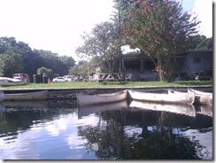
After driving down and checking in at my hotel in the morning, I stopped at Florida Bay Outfitters for a new hat and rash-guard shirt. Since I was there and they’d started selling their rental fleet for the off-season, I also bought a boat … which will bring to five the count of boats in my garage when I pick it up in July.
Now, five boats may seem excessive to some people, but each has its own specific purpose and use. So to
justify myselfexplain each boat’s purpose:- My primary boat is the 16’ Tarpon pictured above. It’s stable, tracks well, and it’s generally comfortable, except for the still-missing
ass-padseat cushion that I still haven’t replaced. - Then I have a Pamlico tandem, which I’ll likely be selling soon, as I have a new rule of never going with someone who won’t paddle their own damn boat.
- Next is a 9.5’ Swifty that’s mostly used by my daughter, but it’s a light, handy, cockpit boat that’s nice to throw on top of the car for a quick paddle in the morning or afternoon.
- Lastly is an Ocean Kayak surf boat which I got
to have a surf boatfor the boy-child to use.
The new boat will be a 14’ Tarpon 140:
This will give me a boat similar to my primary, but a bit shorter (easier to control) for when I want to take someone who doesn’t have their own boat. In addition, it has a rear well instead of a hatch, so it’ll comfortably hold dive gear.
See? I absolutely need five boats …
Friday Afternoon – Lignumvitae Key
2.5 hours – 5.5 miles
My plan for the weekend was to paddle the three Keys accessible from the causeway between Upper and Lower Matecumbe Keys, Lignumvitae, Shell, and Indian Keys, with a possible diversion to snorkel at the wreck of the San Pedro (about a mile south of Indian Key):
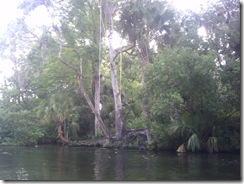
I took a quick paddle around Lignumvitae – it was a beautiful day, with little wind and crystal clear water. On the way back across the flats, I passed a 3’-4’ nurse shark cruising along the bottom.
Saturday & Sunday
The weather forecast for the weekend called for 15+mph winds. When I arrived at the put-in Saturday morning, it was clear that the wind would be an issue on either the Gulf or Bay sides, so I took the opportunity to spend the day in Key West.
That turned out to be a good decision, as the beach rental at Smather’s Beach in Key West claimed 20-30mph winds and Bahia Honda wasn’t even renting kayaks because of the wind.
More of the same on Sunday, so I drove to Everglades National Park and spent the day there.
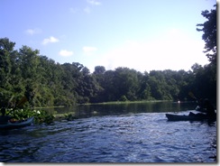
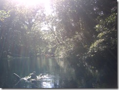
Monday Morning – Blackwater Sound
3.75 hours – 10.3 miles
The forecast for Monday called for 10mph winds dropping to 5mph in the afternoon. I put-in at Florida Bay Outfitters and paddled across Blackwater Sound to Dunedin Creek, taking a bit of a detour into the mangrove creeks to explore.
Coming out of Dunedin, I made for the western edge of Little Buttonwood Sound, which put the paddle at five miles. My plans were to head west from there toward Porjoe Key and then on to North and South Nest Keys.
At this point, though, the winds did not seem to have died down and were out of the East and Southeast, so continuing the trip another five miles to Nest Keys would mean a ten mile return mostly into the wind – with the first half of it giving the wind a five mile fetch across open water.
If I’d had camping gear with me, I’d have taken the chance, knowing I could just stay overnight and paddle back the next day. In fact, I think I’ll do that next time.
- My primary boat is the 16’ Tarpon pictured above. It’s stable, tracks well, and it’s generally comfortable, except for the still-missing
-
Saint Joseph Sound Spoil Islands
December in Florida. On the water at 11:30, clear blue skies and 72-degrees.

This was a trip to visit the spoil islands in Saint Joseph Sound to pick one for camping in a few weeks. Spoil islands are the result of dredging channels – the material dredged from the bottom of the channel is loaded on a barge and the barge is periodically dumped to the side of the channel.
This results in evenly spaced islands (or bars if there wasn’t enough material) along the line of the channel. In this case there are six islands about a half mile apart running north of the Dunedin-Honeymoon Island causeway. The channel continues to the north, but the islands stop – the northern dump sites didn’t rise to the level of islands.

(open in Google Earth)
(7 miles – 3:30)There’s a lot of rock and oyster shell around the causeway and islands, much of it exposed at low tide, which is when I arrived to put in. The oyster shell will tear up a boat faster even than rock, so don’t drag your boat over it. Also watch your step, as it’ll slice your feet up just as easily.

I set course for the first island in the chain and started off. Getting there from where I put in on the causeway meant crossing the boat channel. I always laugh at kayakers who start talking about marine law and right-of-way regarding powered boats. In my book, right-of-way goes to who won’t wind up as flotsam and chum after the collision, so I always make sure the channels are clear for a long ways before trying to cross.
This is not clear enough:

The reason we wait until it’s completely clear, of course, is because no matter how well the day’s going, no matter how swift your stroke is … dead center of the channel will be the spot your cooler decides to slide off the back deck of the boat and become a sea anchor. Did this happen today? Of course it did. This is why I want a new boat.
On some of the islands, local conservation groups are busily at work replacing non-native vegetation. While I can agree with this in principal, I still think the Australian pines just look better than native growth.

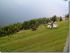
The first and second islands north of the causeway have rock fire pits and cleared areas suitable for camping. The second is larger and someone has brought in a picnic table.


Both were nicely free of trash, with only a few cans or bottles around. Most of these had already been placed in the fire pits.
On the first island, though, there’s clearly a “bathroom” area that some people aren’t following “leave no trace” in.

If you can’t handle packing it out, then stay somewhere there’s a toilet.
The third island north of the causeway is an Audubon sanctuary, so landing is not permitted. The fourth was inaccessible during my trip due to the tide – exposed rock and oyster shell made landing a bad idea.


Island five had a little surprise in store for me. The low tide exposed a spit of sand and an odd looking rock that turned out to be this little guy:

Not every day that you see one of these on the beach.
The last island in the chain is small and rocky, with only a few scrub trees for cover.

Even so, if the weather forecast is good, it will probably be my choice for camping, because it’s isolated and well-positioned as a base. From here, it’s only two miles to either Honeymoon (red) or the bars north of Honeymoon (green), and from them it’s only another two miles to Anclote (blue).

-
Things I Want to Do
This is the Florida-list of paddles I want to do and doesn’t include U.S. or world trips.
7-Mile Bridge
I’ve always found it a bit strange that for all the time I’ve spent in the Keys I’ve never paddled 7-Mile Bridge.
I’ve paddled a lot of the areas around it, but for some reason never just did the paddle from one bridgehead to another. There’s nothing particularly special about the route, it’s something you do just to say you’ve done – and I haven’t yet.
Suwannee River
I’ve paddled portions of the Suwannee, including Florida’s rapids, but paddleflorida.org has an annual trip that sounds like an absolute blast.
View Suwannee Music Camp to Manatee Spr in a larger mapEight days and 123-miles of paddling and camping. Breakfast and dinner catered with sandwiches at the lunch stops. And a shuttle for the beginning or ending of the trip.
In my younger, more foolish and less achy days, I might have scorned this sort of trip, scoffing that rehydrated eggs were the only breakfast a real camper needs, but as I’m now older, and ostensibly wiser, catering and the occasional shower doesn’t sound so bad.
This is a trip I may take this year, as it’s upcoming in October … of course, I’ve said that the last three years and not made it. 🙁
And the popularity of their trips seems to be growing, with five other paddles on various waterways planned for the next year.
The Florida Circumnavigational Trail
I’ve written about this before. Obviously completing this journey is more than one trip, but if I want to do it, I need to start soon, I think.
Because of the distances involved, though, I need to find a
crazy personpartner willing to undertake it with me – arranging this number of shuttles over these distances would be problematic. Two cars and a paddling partner would be preferable.Hopefully a partner able to take a long weekend every couple of months and paddle a segment – four years, maybe, to finish the whole thing at that pace?
-
Honeymoon Island
I had a bit of a later start than I planned this morning, due mostly to a muttered “oh, hell, no” and slap at the alarm clock around 0-dark-thirty.
Once up, though, I loaded the car and hit the road for Dunedin, FL, stopping just twice:
- Subway for breakfast and lunch – their new breakfast is pretty good, easily in the top five of semi-fast-food, after Panera, Starbucks and Chick-Fil-A, and the cheapest of the four. Quite a bit above McDonald’s or Burger King. Plus you can pick up a cooler-friendly lunch at the same time.
-
The Best Buy in Dunedin to pick up an iPhone battery. Yes, I know you can’t replace the battery in them. I was looking for either a solar charger or charger that uses regular batteries, because I’ve been using the iPhone as my GPS tracker on trips (safely ensconced in the deck bag, of course), but the GPS eats battery life. What I found was this thing from Energizer that works as an external rechargeable battery:
So far, so good – it ran the iPhone for GPS tracking over four hours today and the phone still had a full charge.
A good put-in to paddle either Honeymoon Island or nearby Caladesi is from the Dunedin Causeway.
View Dunedin Causeway in a larger mapView Dunedin Causeway Put In in a larger map
You can enter the state park on Honeymoon Island, but the portage from parking lot to beach is a lot longer than on the causeway:
Of course I still haven’t repaired the seat padding that blew off, so I had to improvise an
ass-padcushion.All in all a folded towel is okay, except for the part where it gets saturated and you sit around in salt-water all day … but the Tarpon’s a wet boat anyway, so I didn’t really notice.
My goal today was to circumnavigate Honeymoon Island then paddle around St. Joseph Sound on the east side of Caladesi. With the late start and the stops, I only managed the first half of that.
GPS tracking powered by InstaMapper.com
The weather forecast called for the winds to be out of the ESE between 8 and 12 MPH, so I started my trip on the east side of the island (going counterclockwise), putting the wind and waves at my back and quarter for the first part of the trip.
I did have to paddle into the stronger wind for the latter part of the trip down the west side of the island, but it was a much shorter distance to face that than the east would have been. You can see from the GPS track that I was a lot slower on the West side, especially when I got far enough south to be out of the lee of the island.
I passed near Grassy Key on my way north, a small mangrove island.
Most of the southeast portion of Honeymoon is mangrove also, with no beaches or stopping places.
It’s not until you round the northernmost headland of mangroves that the shore begins to offer places to beach.
I stopped three times on the east side of the island.
The first stop was because I had to pee. I know, TMI, but under the Florida sun: If you don’t have to pee, you’re not drinking enough. Something Florida paddlers should keep in mind. I also picked up about a dozen cans and bottles at this stop to dispose of properly.
The second stop was because I thought I remembered there being an easy portage spot there – clearly I was mistaken, since that stop was at about the widest part of that portion of the island. So much for my memory.
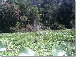
And the third stop was because an osprey had perched on very low post.
The wind and waves were driving me right to the beach at the base of this short dune, so I was able to keep still and exit the boat out of his site. This let me get a lot closer for a picture.
The north end of Honeymoon is roped off and signed as restricted to protect nesting birds. The sandbar there is also a gathering spot for the feathered ones.
Rounding the north end of the island presents you with a view of the open Gulf.
The ocean-side of Honeymoon should be considered an open-water paddle. Unlike the sheltered sound to the east, the west-side can get the full force of wind, waves and currents. A basic understanding of currents and tides is helpful and you should be comfortable having nothing on one side of you until Mexico.
The combination today was a light wind out of the south and a moderate swell out of the south. Since I had to go south, this made the second half of today’s paddle more challenging. But I find swells easier to handle than the chop the wind was kicking up on the east side, so I’m glad I went counterclockwise today.
The northern beaches on Honeymoon are the farthest from the parking lots, so they’re not very crowded.
But this changes as you head south.
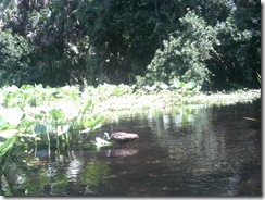
I saw only one dolphin on this trip, that just as I was turning east around the south end of the island. I wasn’t able to get a picture, because he only surfaced twice, both times quickly and heading north.
I pulled onto the beach at the very southern tip of the island, just before the channel and crossing to Caladesi, where I had a quick lunch. As soon as I had my sandwich in hand, this guy showed up to try mooching a bite.
His presence also irritated a couple other gulls who were busy with the preliminaries to seagull sex.
After lunch, I crossed the channel to the Caladesi side.
But I decided to call it a day and head for the causeway and home.
-
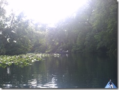
Wekiva River
After nearly soiling myself passing a very large gator at close range on the Econlockhatchee, I decided something more leisurely and sedate was in order, so I headed for Wekiwa Springs State Park to paddle the Wekiva River.
The springs and the river actually do have different names, it isn’t an alternate spelling. Wekiwa refers to the springs — water coming out of the ground; while Wekiva means water flowing over the ground.
If you want a peaceful, tranquil Florida river experience, the Wekiva is a good choice … unless it’s a Saturday during Summer. Wekiwa Springs State Park frequently closes due to capacity being reached on Summer weekends and the river teems with boaters … most of them in rented canoes with no idea what they’re doing and less interest in the serenity of nature.
Near the headwaters of the Wekiva you have a choice of putting in at either the State Park or Wekiva Marina (about a mile downstream from the springs).
I chose the State Park because the fee to put in is a couple dollars less. If you put in at the Marina and then want to paddle to the Park, there’s a small fee to enter the Park as well.
One issue with launching your own boat from the State Park is that the water is some distance from the parking. There’s also a hill involved and the trail is rather soft sand in some places. It’s not that bad getting to the water, since it’s downhill from the parking lot … the bad part comes later.
The put-in is on the Wekiwa Springs pond, just below the swimming area.
Since my little misadventure on the Econ had eaten up some of my time this morning (and thankfully that was all that was eaten), it was after 9:00 AM when I got to the springs and people were already on the water. It was still early enough, though to get a bit of mist and early morning sunshine through the trees.
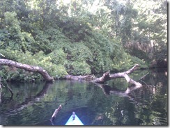
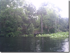
About 3/4 of a mile from the springs, Rock Springs Run joins the Wekiva. This is a smaller, less-traveled tributary that I enjoy paddling and I started up it a bit before returning to the Wekiva.
A full mile from the State Park is Wekiva Marina, where you can also put in or rent a canoe.
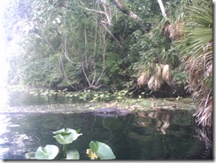
Shortly past the marina, I came across a small alligator — a much more pleasant encounter than the one earlier in the day. In fact, on most trips down the Wekiva I’ve encountered a small gator in this area, just downstream of the marina.
It’s at this point in writing this blog entry that I come to the realization that the little Argus Bean camera I got for these trips just isn’t going to do it for me. Most of the pictures I took on this trip didn’t come out well, so I’m going to have to try something better.
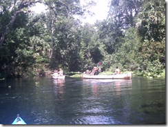
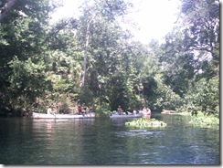
After pointing out the little gator to the next group of paddlers coming down the river, I leave him behind and encounter a new form of wildlife — kayaker without PFD:
If you look closely, you can see her head behind the nice Fish and Game officer’s boat … her head’s right next to the officer’s ticket book, which she got a very good look at.
Is it really such a hardship to have a PFD in the boat?
Past the legal action, I saw bubbles start to break the surface of the water near the shore, then a stream of bubbles race across the width of the river. A line of bubbles breaking the surface usually means an otter and a bit of patience tracked him down when he surfaced near a fallen tree to munch on a fish.
I love watching otters and had the good fortune to once rent an apartment that had been built around a natural pond that acquired a family of them. For several months I was able to watch them from the comfort of my balcony:
After passing the otters, I saw some turtles on a log:
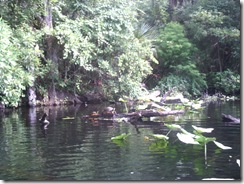
This is the obligatory, Florida, Turtle on a Log picture. I do not plan to take or post any more pictures of Turtle on a Log, no matter what river I see them on.
Now, don’t get me wrong, I like seeing Turtles on a Log — no matter how many times I see them, it’s a nice reminder that I’m on the water, away from the city. But, let’s face it, there’re a lot of Turtles on a Log. And anyone who paddles, especially in Florida, has seen more than their share already, so pictures of them aren’t really necessary.
So, from time to time, if I feel it’s useful for the ambiance of the trip report, I’ll just throw in:
You’ll know what I mean and it’ll save everyone’s time and Internet bandwidth. If you truly feel compelled to see another picture of Turtle on a Log, you can click the link and come right back here to one.
Of course, I’ll still take and post a picture if I feel it’s noteworthy, for instance if I see Unusually Large Turtle on a Log or Very Large Number of Turtles on a Log. Definitely if I see the very rare: Log With No Turtle.
I started paddling again …
(see how nicely that works?)
About 1/2 a mile downstream of the marina, the river appears to split around an island you can recognize by the lone palm tree next to a bare bank:
The left channel is the main, navigable river, but the island is a frequent stop to rest and relax. Farther along its shore are several rope swings and later in the day this spot will be packed with people picnicking and playing in the water.
The rest of my paddle down river is mostly uneventful …
<Turtle on a Log>
<Turtle on a Log>
<Turtle on a Log>… though I do get my best quality pictures of the day out of the Argus Bean when I come to an open area of the river and want to capture the beautiful sky I’m paddling under:

After a couple hours of paddling …
<Turtle on a Log> ^ 10
I do encounter some very tolerant birds that let me get quite close for a picture. These are without any zoom:
Once back between the marina and the park, I once again encounter the large crowds on the river this summer weekend. The attendant at the springs put-in told me they had eighty boats on the water — possibly an exaggeration.
One day, I’m going to come here and just paddle the mile between the park and marina, back and forth, all day, watching the people in the rented canoes. Some know what they’re doing, but for others it’s a crap-shoot whether they’ll make it off the river alive.
Best quote of the day (from a wife in the front of a canoe with a paddle across her lap):
"You’re heading right for another tree!"
The tree in question was at least fifty feet away and the look on the husband’s face was priceless.
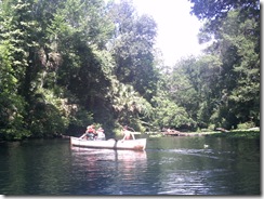
My favorite was this lady. She has three kids with her in two canoes. She has tied the canoes together and is the only one paddling — the kids mostly just sit there with their paddles. Here she is crossing the river in front of me:
Now, here she is crossing the river back the other way:
And back:
Here the Bean failed me again, but she’s recrossing the river right in front of another canoe (keep in mind her two are tied together and the oncoming canoe has the current behind it). I’m cringing at this point, waiting for the clothesline flag to be thrown and ready to assist the soon-to-be victims.
Luckily, the oncoming paddler was able to slow down enough to avoid disaster.
Once back at the State Park put-in, the truly horrid part of the trip is facing me: getting the boat back to the car.
After trudging up the hill to retrieve the kayak cart from the car and back down to the put-in, I make sure everything’s secure on the boat and start the trek … uphill … through the soft, soft sand.
At the top of the initial hill, there’s a choice to be made. I can turn right past the concession stand and then up the narrower, steeper trail to where I parked, or I can go left through a picnic area — that way is longer, but not as steep.
I’m 41-years old, out of shape and need the exercise, I take the hill. Besides, they’re grilling in the picnic area, I can smell it. I’m hungry after the morning’s paddling and the turkey sandwiches waiting in my cooler just aren’t what I want. If I have to drag this damn boat past burgers and barbeque, there’s going to be an Incident.
So up the hill. But not all at once. The goal is to get the heart pumping, not exploding.
First, the short pull across level ground to the restrooms, which is an excellent excuse to stop for a moment. Then start up the hill to the gate and pause again, looking longingly back at the hot dog cart outside the park’s concession. If they were grilled, I’d be all over it, but they’re boiled and even the turkey in the cooler’s more appetizing than that.
Now up the hill to the halfway point, where I wheeze for a little while, muttering about how if I’d taken the other path I’d be eating a burger right now while fending off its owner with a BBQ fork.
And one final pull to the parking lot where I load up the car and settle in to the air conditioning to eat my turkey sandwich. Yum.
-
Florida Circumnavigational Paddling Trail
 Twenty-six segments of multi-day paddling to completely circumnavigate Florida from the Panhandle to the Georgia border … what more can I say?
Florida Paddling Trails Association (the volunteer stewards of the trail)
-
Introduction
This site was born out of my frustration with being unable to find paddling sites that provided all the information I’d like to have about a new destination.
For instance, I’ve never seen a description of taking out at Wekiva Springs State Park that lays out just how painful the two-hundred yard uphill trudge through soft sand from the river back to the parking lot will be. Or that the Snow Hill Road take-out on the Econlockhatchee River has been rebuilt by the County with anti-erosion measures that will tear up the bottom of a boat.
Good maps, both road maps to the put-in or take-out and maps of the water itself seem unusually hard to find, as well.
So in these trip reports I’m going to try to provide the kind of information I’d be looking for when investigating a new destination … hopefully you’ll find it useful as well.


