Your cart is currently empty!
Category: wekiva
-
Afternoon on the Wekiva
An afternoon paddle on the Wekiva today, but no pictures or GPS due to battery issues. Those should be resolved before my next paddle, though.
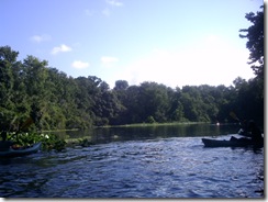
I started at Wekiva Springs State Park and turned onto Rock Springs Run to paddle upstream until the water became to shallow to continue. Then I returned to the Wekiva and paddled downstream past the marina for an hour or two.
Two small gators, a number of birds, and a bevy of drunken paddlers from the marina. The highlight of the trip was a hawk carrying a squirrel (or some other small, furry dinner) that back-winged mid-river to reach a tree on the bank.
Part of this trip was to try out a couple pieces of new equipment.
First was a carry strap I got from topkayaker.net:
(stock photo – sadly neither the yak nor the brunette are mine)
I’ve used this the last couple trips, but those were short transfers. It worked well for those, but the 100-yard sand path from the parking lot to the launch at the Park would be a good test, with soft sand much of the way that tends to bog down some kayak cart wheels and a significant elevation change between the parking lot and the launch area.
So what I found was that the weight, even on one shoulder, wasn’t a problem. The 16’ length of the Tarpon is an issue, as it’s simply unwieldy to carry – controlling the ends, and such. The biggest issue for a long portage with this device is that the bottom of the boat presses against my leg just below the knee – so each step rubs that spot back and forth along the bottom edge of the boat.
On the trip down to the water the kayak had been on top of the car for a couple hours, so had plenty of time to heat up the plastic and it was uncomfortable. On the way back up again, the friction was noticeable – in fact, I believe there is a spot bare of hair on that leg now. Next time I’ll have to bring some pants to change into for the portage – that should alleviate the rubbing.
Next were these:
I’ve been looking at the Vibram Fivefingers brand for a while and my kayaking sandals are just about at the end of their useful life, so I decided to try a pair.
These are the KSO model, along with the Flow, designed for watersports.
So comparing them to the sandals I usually wear, I was favorably impressed. Yes, the having-stuff-between-your-toes thing takes a bit of getting used to, but aside from my left pinky-toe, all adjusted quickly and even that awkwardness went away once they got wet the first time.
I was in and out of the boat several times and when the water got very skinny on Rock Springs Run I got out and walked for a couple hundred yards pulling the boat.
The “feel” of these is very much like being barefoot, but still protected from rocks and logs. I didn’t have a need to perch on a log while pulling the boat over, but I do think these would provide better grip and balance than sandals.
The bottom of Rock Springs Run is more sand than mud, but there are spots where the sand isn’t hard-packed and your feet sink. These were easier to deal with in the KSOs than in sandals. With sandals, once you’re foot sinks, pulling it out often creates a void between the sole of your foot and the sandal – that creates some suction and makes it more difficult to get out. These both stay on and avoid that problem.
The fit around the ankle is tight enough that very little sand or dirt is able to get into the shoe.
Overall quite comfortable and effective.
-
Two Mondays on the Wekiva – Part II
For today’s trip on the Wekiva, I headed for Wilson’s Landing at State Road 46 to put in.
View Wekiva – Wilson’s Landing in a larger mapThe forecast all week calls for scattered thundershowers and halfway to drop my daughter off for her class and my couple hours on the water I ran into this.
 Traffic on the 70 MPH highway slowed to 40 as the storm cut visibility, but it soon cleared a little.
The SR46 bridge is off-limits for boat launching, but Wilson’s Landing is close by. There’s no official boat launch at the park at this time, but Seminole County recently approved a quarter million dollars to build a pavilion and launch there.
Frankly, I think I could build a pavilion and canoe launch for a lot less than $250,000, but that’s a different issue.
Until it’s built, though, launching is a little … unofficial.

Parking is a good distance from the water, but there’s a paved sidewalk most of the way (if you have wheels) and terrain’s mostly level (unlike Wekiwa Springs State Park). There’s also a dirt road that continues past the parking to a roundabout that gets you about halfway closer to the water.
The sidewalk leads to a boardwalk over the water, but there’s a dirt path branching off it to the only clear area of shoreline in the park.
 The path is surrounded by landscaping, but hasn’t been landscaped itself and there are no signs prohibiting boat launching, so I’ve assumed it’s okay to use this spot until the official launch site is built.
The site itself, though, is pretty cramped right now and it’s a bit tricky to maneuver a large boat onto the water and back to shore for boarding.
 Once on the water, you can see that you’re only a short distance from the SR 46 bridge.
 I had limited time for this trip, starting at 5:00 and needing to be off the water by 7:00 in order to pick up my daughter at 7:30, so I started upstream – planning to paddle until six and then head back to my launch point.
GPS tracking powered by InstaMapper.com
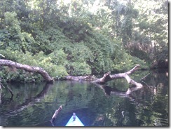
Shortly into the trip, though, I found that staying by the right-bank had been a mistake and the channel I’d followed became clogged and impassable.
 After heading back downriver, I decided to keep going that way, rather than retracing my path nearer the left-bank, so I headed for the bridge, taking a couple photos along the way.

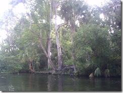
 The Wekiva’s an interesting river, because it can change from the very open river I started paddling in to a much closer, tree-lined river in a very short distance – as it does, just after the bridge, splitting into two channels with a tree-covered island between them.
 And then opening up again just as rapidly.
 Ducks were out in force this trip and I saw quite a few of them.
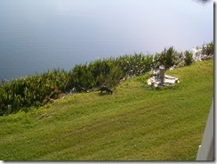
 And farther down river, two deer were getting an early dinner.
 You’d think after almost forty years in Florida, I’d know what some of these damn birds are, but I really have no idea. I got a decent picture of this thing, though.
 And to think the mess I’d driven through earlier turned into this:
 Ducks I can recognize, though, and this one seemed to not care at all about me.

 By this time it was six and time to turn around, but looking ahead I could see that I wasn’t nearly out of river yet …
Surely I could paddle a little farther and still make it back in time? Right? I decided to paddle until 6:15 and then head back.
And I’m glad I did, because just a little ways downstream an alligator left the reeds ahead for the far side at my approach.

 He was followed by a second, larger one, who reached the far shore and then paralleled my course for a while.
 Shortly thereafter, I ran across this plant – not sure what it is, but it looks nice.
 At this point, it’s 6:08, so I decide to turn around and head back … mostly because my watch is slow and it’s really 6:12.
Remember all those big open spaces on the river … well, now the current’s against me and the wind seems to have picked up and is funneled between the trees and I have to hurry back to the put in.
 Why does this little stretch of river seem so much harder to paddle than the open-ocean side of Honeymoon was Friday?
 Finally, ahead of me, the river splits and I paddle into the narrower channel on the right-bank. Once I’m through this tree-covered area, I’ll be going under the bridge and then it’s just a few hundred yards to the park.
 Doh!
Doh! Not quite at the right split yet, and the homeowners have built a wall across the river – probably too many boats cruising through ignoring the No Wake signs. So I have to backtrack and get out of this dead end, but if I hadn’t taken it, we wouldn’t have this picture of a pony in someone’s back yard.
 Yes, the best picture I could get was of the horse’s ass. I’m in a hurry and have to get off the water by 7:00 or I’ll be late picking up my daughter – give me a break.
As an aside, is that really a pony, or is it a demondonkey?

I’m just asking.
Saw another large alligator cruising ahead of me, but he submerged before I got close enough for a photo. And now that I’m hurrying, fighting against the current and the wind to get back and off the water by 7:00 so I won’t be late for that 7:30 pick up, there’re smaller gators on every freakin’ dock I pass, it seems. No time for pictures of them, though.
Finally, I’m in the right channel and reach the bridge.
 And back to Wilson’s Landing where I can get off the water.
 Yes, that’s the target I have to line my 16’ boat up against, get close enough sideways to step out onto land, then maneuver the boat around to pull it out. I didn’t say it was an easy site.
Off the water, drag all the gear back to the roundabout, load the car and ready to drive only a few minutes late.
 My schedule had some buffer time in it, so I’m able to make it with a couple of minutes to spare, arriving to pick my daughter up at 7:28.
 At which time, I sit around and wait until 7:45 because her class ran long.
-
Two Mondays on the Wekiva – Part I
I was lazy last week and didn’t post about one of my trips, so will have to take care of that today.
In the past when I’ve tried to get back to paddling, one of the problems has been time. With a family there always seems to be something that needs to be done, so the “not enough time” excuse rears its head. This time, though, I’m working on the theory that two hours on the water is still two hours on the water, so I’m taking opportunities as they arise.
So since my daughter has classes several times a week, I’ve started taking the opportunity to do something other than drive home and sit on the couch before it’s time to pick her up – whether paddling or hockey or something else.
Under this premise, a friend and I headed for Wekiwa Springs State Park Monday (5/10) to get on the water.
View Wekiva River in a larger mapWith two people, the portage from the parking lot to the water wasn’t too bad and we headed out.
GPS tracking powered by InstaMapper.com
The GPS went a little hinky and didn’t track as often as it should have, but we first headed up Rock Springs Run until the water got so shallow in spots that we had to get out and pull the kayaks.
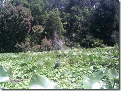
This bird was there on our way up Rock Springs Run and didn’t budge as we went by. After we paddled upriver for a while and came back, he was still there – apparently unmoved. We considered the possibility that he was some taxidermists prank until we got close enough to make him stalk off indignantly.
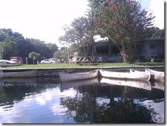
Once off Rock Springs Run and back on the Wekiva, we found the Wekiva Marina much changed since my last visit and pretty busy for a Monday afternoon.
Last time I was on this river, the marina was pretty dilapidated and didn’t get much traffic. It looks like things have had significant changes. I’m going to have to stop by and check it out.
Further down the river, we came across this little place, posted No Trespassing by the Florida Farm Bureau.
Not sure why it’s there or what it’s used for.
Not much wildlife on this trip, but all along the route we saw signs of the most invasive species in Florida.
I really don’t understand how people who go out on the river and clearly enjoy doing so can so casually toss crap everywhere – do they not care if they’re swimming and fishing in a garbage dump?
-
Wekiva River
After nearly soiling myself passing a very large gator at close range on the Econlockhatchee, I decided something more leisurely and sedate was in order, so I headed for Wekiwa Springs State Park to paddle the Wekiva River.
The springs and the river actually do have different names, it isn’t an alternate spelling. Wekiwa refers to the springs — water coming out of the ground; while Wekiva means water flowing over the ground.
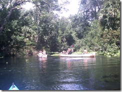
If you want a peaceful, tranquil Florida river experience, the Wekiva is a good choice … unless it’s a Saturday during Summer. Wekiwa Springs State Park frequently closes due to capacity being reached on Summer weekends and the river teems with boaters … most of them in rented canoes with no idea what they’re doing and less interest in the serenity of nature.
Near the headwaters of the Wekiva you have a choice of putting in at either the State Park or Wekiva Marina (about a mile downstream from the springs).
I chose the State Park because the fee to put in is a couple dollars less. If you put in at the Marina and then want to paddle to the Park, there’s a small fee to enter the Park as well.
One issue with launching your own boat from the State Park is that the water is some distance from the parking. There’s also a hill involved and the trail is rather soft sand in some places. It’s not that bad getting to the water, since it’s downhill from the parking lot … the bad part comes later.
The put-in is on the Wekiwa Springs pond, just below the swimming area.
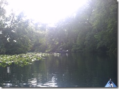
Since my little misadventure on the Econ had eaten up some of my time this morning (and thankfully that was all that was eaten), it was after 9:00 AM when I got to the springs and people were already on the water. It was still early enough, though to get a bit of mist and early morning sunshine through the trees.
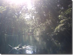
About 3/4 of a mile from the springs, Rock Springs Run joins the Wekiva. This is a smaller, less-traveled tributary that I enjoy paddling and I started up it a bit before returning to the Wekiva.
A full mile from the State Park is Wekiva Marina, where you can also put in or rent a canoe.
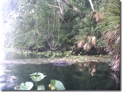
Shortly past the marina, I came across a small alligator — a much more pleasant encounter than the one earlier in the day. In fact, on most trips down the Wekiva I’ve encountered a small gator in this area, just downstream of the marina.
It’s at this point in writing this blog entry that I come to the realization that the little Argus Bean camera I got for these trips just isn’t going to do it for me. Most of the pictures I took on this trip didn’t come out well, so I’m going to have to try something better.
After pointing out the little gator to the next group of paddlers coming down the river, I leave him behind and encounter a new form of wildlife — kayaker without PFD:
If you look closely, you can see her head behind the nice Fish and Game officer’s boat … her head’s right next to the officer’s ticket book, which she got a very good look at.
Is it really such a hardship to have a PFD in the boat?
Past the legal action, I saw bubbles start to break the surface of the water near the shore, then a stream of bubbles race across the width of the river. A line of bubbles breaking the surface usually means an otter and a bit of patience tracked him down when he surfaced near a fallen tree to munch on a fish.
I love watching otters and had the good fortune to once rent an apartment that had been built around a natural pond that acquired a family of them. For several months I was able to watch them from the comfort of my balcony:
After passing the otters, I saw some turtles on a log:
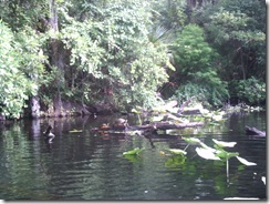
This is the obligatory, Florida, Turtle on a Log picture. I do not plan to take or post any more pictures of Turtle on a Log, no matter what river I see them on.
Now, don’t get me wrong, I like seeing Turtles on a Log — no matter how many times I see them, it’s a nice reminder that I’m on the water, away from the city. But, let’s face it, there’re a lot of Turtles on a Log. And anyone who paddles, especially in Florida, has seen more than their share already, so pictures of them aren’t really necessary.
So, from time to time, if I feel it’s useful for the ambiance of the trip report, I’ll just throw in:
You’ll know what I mean and it’ll save everyone’s time and Internet bandwidth. If you truly feel compelled to see another picture of Turtle on a Log, you can click the link and come right back here to one.
Of course, I’ll still take and post a picture if I feel it’s noteworthy, for instance if I see Unusually Large Turtle on a Log or Very Large Number of Turtles on a Log. Definitely if I see the very rare: Log With No Turtle.
I started paddling again …
(see how nicely that works?)
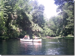
About 1/2 a mile downstream of the marina, the river appears to split around an island you can recognize by the lone palm tree next to a bare bank:
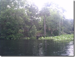
The left channel is the main, navigable river, but the island is a frequent stop to rest and relax. Farther along its shore are several rope swings and later in the day this spot will be packed with people picnicking and playing in the water.
The rest of my paddle down river is mostly uneventful …
<Turtle on a Log>
<Turtle on a Log>
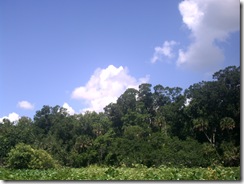
<Turtle on a Log>… though I do get my best quality pictures of the day out of the Argus Bean when I come to an open area of the river and want to capture the beautiful sky I’m paddling under:

After a couple hours of paddling …
<Turtle on a Log> ^ 10
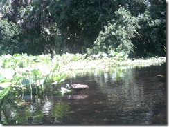
I do encounter some very tolerant birds that let me get quite close for a picture. These are without any zoom:
Once back between the marina and the park, I once again encounter the large crowds on the river this summer weekend. The attendant at the springs put-in told me they had eighty boats on the water — possibly an exaggeration.
One day, I’m going to come here and just paddle the mile between the park and marina, back and forth, all day, watching the people in the rented canoes. Some know what they’re doing, but for others it’s a crap-shoot whether they’ll make it off the river alive.
Best quote of the day (from a wife in the front of a canoe with a paddle across her lap):
"You’re heading right for another tree!"
The tree in question was at least fifty feet away and the look on the husband’s face was priceless.
My favorite was this lady. She has three kids with her in two canoes. She has tied the canoes together and is the only one paddling — the kids mostly just sit there with their paddles. Here she is crossing the river in front of me:
Now, here she is crossing the river back the other way:
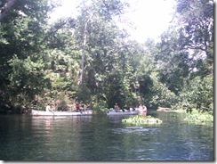
And back:
Here the Bean failed me again, but she’s recrossing the river right in front of another canoe (keep in mind her two are tied together and the oncoming canoe has the current behind it). I’m cringing at this point, waiting for the clothesline flag to be thrown and ready to assist the soon-to-be victims.
Luckily, the oncoming paddler was able to slow down enough to avoid disaster.
Once back at the State Park put-in, the truly horrid part of the trip is facing me: getting the boat back to the car.
After trudging up the hill to retrieve the kayak cart from the car and back down to the put-in, I make sure everything’s secure on the boat and start the trek … uphill … through the soft, soft sand.
At the top of the initial hill, there’s a choice to be made. I can turn right past the concession stand and then up the narrower, steeper trail to where I parked, or I can go left through a picnic area — that way is longer, but not as steep.
I’m 41-years old, out of shape and need the exercise, I take the hill. Besides, they’re grilling in the picnic area, I can smell it. I’m hungry after the morning’s paddling and the turkey sandwiches waiting in my cooler just aren’t what I want. If I have to drag this damn boat past burgers and barbeque, there’s going to be an Incident.
So up the hill. But not all at once. The goal is to get the heart pumping, not exploding.
First, the short pull across level ground to the restrooms, which is an excellent excuse to stop for a moment. Then start up the hill to the gate and pause again, looking longingly back at the hot dog cart outside the park’s concession. If they were grilled, I’d be all over it, but they’re boiled and even the turkey in the cooler’s more appetizing than that.
Now up the hill to the halfway point, where I wheeze for a little while, muttering about how if I’d taken the other path I’d be eating a burger right now while fending off its owner with a BBQ fork.
And one final pull to the parking lot where I load up the car and settle in to the air conditioning to eat my turkey sandwich. Yum.
-
Introduction
This site was born out of my frustration with being unable to find paddling sites that provided all the information I’d like to have about a new destination.
For instance, I’ve never seen a description of taking out at Wekiva Springs State Park that lays out just how painful the two-hundred yard uphill trudge through soft sand from the river back to the parking lot will be. Or that the Snow Hill Road take-out on the Econlockhatchee River has been rebuilt by the County with anti-erosion measures that will tear up the bottom of a boat.
Good maps, both road maps to the put-in or take-out and maps of the water itself seem unusually hard to find, as well.
So in these trip reports I’m going to try to provide the kind of information I’d be looking for when investigating a new destination … hopefully you’ll find it useful as well.


